From Paper to Platform
How a six-month pilot of an end-to-end survey-to-maintenance system cut turnaround times, curbed reactive repairs, and laid the groundwork for Golden-Thread compliance.
At a Glance
- ▶
The Challenge of Modern SurveyingHistoric estates and complex structures demand meticulous and efficient surveying. Traditional methods often involve time-consuming manual data collection and fragmented reporting, leading to delays and potential inaccuracies.
- ▶
Technology-Driven PrecisionAdvanced technologies like drone surveying and LiDAR scanning are revolutionizing the field, enabling rapid acquisition of highly accurate point cloud data and detailed digital twins of assets.
- ▶
Streamlined Data to InsightsIntegrated platforms can now consolidate vast amounts of survey data, automate RICS-compliant report generation, and provide actionable insights through intuitive dashboards for estate managers and surveyors.
- ▶
Benefits of Digital TransformationAdopting digital surveying workflows leads to significant time savings, improved accuracy, enhanced collaboration, and better-informed decision-making for cyclical maintenance and preservation of heritage buildings.

A mid-sized UK social-housing provider (≈12,000 dwellings built 1950-2005) still relies on paper checklists and Excel to carry out quinquennial condition surveys and to plan maintenance. Each survey currently requires two site visits and—on average—10 days of back-office effort before a static PDF is issued, resulting in fragmented data that must then be re-entered into the CAFM system. Because defects surface faster than they’re processed, the association spends ≈35% of its annual maintenance budget on unplanned “break-fix” work and struggles to evidence Golden-Thread compliance under the Building Safety Act.
If the provider adopts a cloud platform that unifies on-site data capture, instant report generation, and automatic hand-off to a maintenance-planning module, then:
- Survey-to-report turnaround will fall from 10 days to ≤3 days
- Reactive-repair spend will drop by ≥25% within two years (through earlier detection and scheduled works)
- Compliance audit preparation time will halve
- Collectively delivering a positive ROI inside 18 months
You can validate this by piloting the platform on one regional patch, tracking the time/cost metrics above, and comparing them with control properties that keep the current workflow.
Riverside Housing Association will run a six-month pilot to see whether a new cloud-based survey-and-maintenance platform can transform its workflow. One neighbourhood of about 1,200 homes will act as the “test bed.”
First, the project team will load Riverside’s standard inspection checklist and photo notes into the app and run a short, hands-on workshop so five surveyors and two planners feel confident using it.
All routine condition surveys due in that area will be carried out with the new tool during the first two months, letting surveyors compile reports before they leave site. As each report is finalised, urgent defects will be pushed straight into the maintenance queue instead of waiting for manual re-entry, while lower-priority items feed a rolling five-year works plan.
Throughout the six months, the team will track three simple metrics and compare them with a similar patch that keeps the old paper-and-Excel routine:
- Time from site visit to finished report
- Proportion of budget spent on emergency “call-outs”
- Hours needed to prepare compliance paperwork
Mid-point and end-point reviews will assess savings, staff feedback, and any data-quality hiccups, providing a clear go/no-go decision for rolling the platform out across Riverside’s full 12,000-home portfolio.
Start by assembling a small, cross-functional team (one surveyor, one maintenance planner, one software lead) to map the exact hand-offs where data now falls through the cracks.
In week 1, shadow a live condition survey to capture every touch-point—photos, notes, spreadsheet uploads, report edits—and clock the time spent on each.
In week 2, translate that workflow into a simplified digital journey:
- Single mobile form on site
- Instant cloud sync
- Auto-generated “defect cards” that feed a live maintenance board
By week 4, build a clickable prototype that shows this straight-through flow and test it with three frontline users; refine until they can move from survey completion to scheduled work order in under five minutes.
Secure buy-in from one housing-provider client to run a three-month beta on 100 homes, measuring report turnaround, emergency call-out spend, and compliance-pack prep time.
Use those metrics—and recorded user testimonials—to pitch for seed funding and line up two additional pilot clients, setting the stage for a full SaaS launch focused on survey-to-maintenance integration.
Total Surveys
12
In Progress
2
Completed
10
Reports Generated
120
Recent Surveys
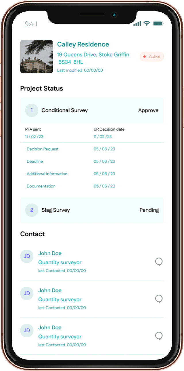
Harrowleigh Manor, Yorkshire, YO24 8HG
Ref: HM-2024-001
St. Augustine's Abbey, Canterbury, CT1 2FB
Ref: SAA-2024-002
Old Mill House, Cotswolds, GL54 1HN
Ref: OMH-2024-003
Victorian Warehouse, Manchester, M1 2HB
Ref: VW-2024-004
Elizabethan Hall, Stratford-upon-Avon, CV37 6QB
Ref: EH-2024-005
At the close of the pilot, the new workflow produced clear—though not flawless—improvements. Report turnaround fell from a lengthy backlog to just a couple of days, liberating a sizeable chunk of staff time that had previously been swallowed by re-typing and formatting.
Unplanned, urgent repairs drew noticeably less of the maintenance budget, even if the reduction did not quite hit its original stretch goal, and compliance packs were assembled in roughly half the time thanks to the live Golden-Thread dashboard.
The vast majority of surveyors adopted the platform once early hiccups with patchy mobile coverage and mismatched asset IDs were resolved during a focused weekend of data clean-up.
Taken together, the efficiencies and cost savings promise to repay the project investment well within the board’s threshold, while highlighting clear next steps:
- Strengthen offline resilience
- Tighten on-site data-validation rules
- Roll out a broader change-management programme before extending the system across the entire portfolio
K E P L E R
L A B S
© 2025 Kepler Labs. All rights reserved.